Why Do Roads Jog: Part 2 of 3
Posted on December 23, 2020
On February 17th, 1815, the War of 1812 ended with the ratification of the Treaty of Ghent. The United States had defeated Great Britain. The treaty included, among other issues, the transfer of British held lands to the United States, opening up the western lands to expansion. The United States became a land-rich nation, which was good because one other bi-products of the war was debt. They owed their armies and allies for their effort, but the US had very little funds with which to pay this debt. Instead, they used land.
President Madison decided to use the land in the Michigan Territories as payment to settle the war debt. Soldiers would be given as much as 160 acres of land depending on their rank at the end of the war. These territories would be the first lands surveyed under the new Public Land Survey System developed by Thomas Jefferson.
The newly created General Land Office (GLO) would be the department charged with the surveys. Edward Tiffin was appointed Surveyor General. In early 1815, Tiffin sent surveyors into the Michigan Territories to begin the surveys. The surveyors quit almost as soon as they had started.
The surveyors had begun their surveys in the southeastern corner of Michigan. The land was barren and swampy. Knowing that the intent of the surveys was to give land to soldiers of the War of 1812, the surveyors wrote to Tiffin, advising him that they were not going to continue the surveys because “not 1 in a hundred, nary 1 in a thousand” acres of land in the Michigan Territory would inhabitable. Governor Lewis Cass heard of the surveyor’s decision and asked the GLO to give the Michigan Territory a second chance. GLO officials returned to the Michigan Territory and Governor Cass took them on a tour of lands in areas that are now Oakland, Macomb, Wayne and Washtenaw counties. The officials were persuaded and the surveyors returned in 1816.
By now, you are wondering when we are going to get to the reason for roads jogging. We’re almost there.
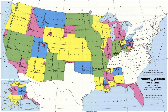
The surveyors were given instructions for the surveys from Edward Tiffin. Those instructions, issued in 1815, provided the surveyors with the process that they were to use to create the townships as designated by Thomas Jefferson and the Continental Congress. A north/south line called the Prime meridian was established. It starts south of Jackson and runs north to Sault Ste. Marie. An east/west line, called the baseline, is established from a point north of Detroit Township and extends westerly to Lake Michigan. A compass was to be used for determination of direction and distances were measured with a half chain, which was 33.00 feet long. In the Detroit area, this line is the centerline of Baseline Road or 8 Mile Road. Then the township exteriors are created. Every half mile around the township exterior, the surveyors were to set a 4”x4’’ wooden post. These posts were also section corners for perimeter sections inside the township. Carvings were made on trees at certain locations as witnessed to the line or witnesses to the wooden post. These locations, marked by wooden posts, will play a part in the reason for a jog in some roads.
At this point, we need to discuss the error in the surveys. Even though most government surveyors did an outstanding job and endeavored to be as accurate as possible, error would play a part. By design, all lines were to be run in cardinal directions (north, south, east and west), and all townships were to be 6 miles square, and sections were to be 1-mile square. Lines that run north, are heading towards the north pole, and converging. So, the north line of a township, will be shorter than the south line if both side lines are run due north. In the interior of the township, section lines were started on the south line of the township and run north for 6 miles to the north township line. These section lines would also converge. Additionally, the instruments, a compass and a chain, were good for the job at hand, but 6 miles through rivers, swamp and brush would almost certainly incur an unknown amount of error. All of these errors were anticipated. It would be the methods used to constrain these errors, or limit these errors, that would be responsible for jogs in our roads.
In Part 3 of 3, we will discuss how the 1815 instructions created procedures to limit error and why these actions created the jogs in roads.

My official signature block says, “Craig P. Amey, PS, Senior Project Surveyor”. I looked up “Senior” in my Encyclopedia Britannica and the definition included words like “elderly”, “older” or the ever-comforting phrase, “in their final years”. Normally, this wouldn’t bother me much, but with the renovations of our office, they replaced my chair with an easy-up recliner, my desk with a TV tray, and my computer with a Sudoku book. Now they’ve asked me to contribute to something called a blog. I am supposed to write about our surveying department and put it on that internet thing. I guess I can write a thing or two, because as the insurance company says, “I’ve seen a thing or two”. I guess I better get writing, right after my nap.