De-Mystifying GIS – What is it and How Can it Work for You?
Posted on July 17, 2020
Allow me to give you a glimpse into a conversation that I and many of my GIS colleagues have had when discussing what we do for a living with a new acquaintance.
“So what do you do?”
“I’m in the GIS department at a civil engineering firm.”
“What is GIS?”
Long, awkward pause…
“I make maps…”
I’ve been doing GIS for 16 years now, and this is often the best I can come up with. For most folks, this is a sufficient enough answer. I make maps. And, in reality, GIS professionals do make maps. Lots of them. But this is a little like saying that firemen just put out fires or doctors can just cure your cold. GIS, or Geographic Information Systems, is such a multi-faceted discipline that it exists in places that you probably didn’t realize it existed.
At its roots, GIS is a vessel for visualizing information in a meaningful and insightful way. As is the case with many data sets, so much of the information has a spatial component to it, whether it’s an address, a zip code or a point of latitude and longitude. Take the COVID-19 pandemic as an example. Healthcare professionals and scientists have developed enormous databases full of information relating to the outbreak, containing records on where cases are occurring, who they are affecting and when the infections were reported. Staring at this information in a large, tabular table like Excel would be daunting for even the most hardened data enthusiast. The answers to many questions can be found within that data, but not realized without a significant amount of digging.
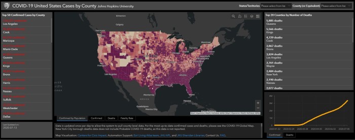
A perfect example of the power of GIS is the wildly referenced COVID-19 Dashboard created by Johns Hopkins University. Utilizing GIS, all of the data found within the myriad COVID databases is summarized, analyzed and presented in an easily understandable format in one singular application. The information can be presented in map format, similar to the map showing cases by state and zip code, or in report summary or graph form, as evidenced by the summary table showing the top 20 counties. To put it another way, Excel isn’t pretty, maps are.
This is one quick example of what GIS can do and how you’ve probably seen it but didn’t realize it. However, there are many other examples of this technology all around you. Take the navigation app in your car or on your phone for example. Employing both a road database and the GPS location of your vehicle, GIS technology is able to analyze the road network and map out the quickest route to your destination of choice. Or how about a simple Google search? When you type in “restaurants near me” into your search, a database containing establishments and their addresses is queried based upon your current location, and the resulting records that are selected are plotted on a google map. Getting a little geekier, and maybe scarier, have you ever used a mobile app created by one of your favorite department stores? While you get the benefit of finding super deals and special offers, those stores get the benefit of knowing where their customers are spending the most time when in store, using that information to optimize product placement and logistics.
GIS is a tool that has been molded to work in nearly every industry in the world. Simply put, data is all around us, and GIS takes that data and makes it readily accessible and easy to understand. Whether it’s finding out which fire hydrants are out of service or finding the nearest Starbucks, we all have grown accustomed to finding these answers quickly. That’s where GIS comes in!

Jeff Miller started his career at AEW as a GIS Specialist in 2006, becoming the GIS Manager in 2015. His work in the GIS field has taken him from Fenton, MI to Boca Raton, FL to Mesa, AZ, and finally back to AEW (just testing out retirement locations, apparently…). Jeff graduated from Central Michigan University in 2004 with a degree in Geography with GIS and Land Use Planning concentrations. When he isn’t administering AEW’s Enterprise GIS environment, he enjoys playing all sports, camping, listening to GOOD music and learning to play the piano, albeit very slowly…