Field Applications Utilizing Collector for ArcGIS
Posted on June 4, 2020
June, 2020
Ah, the old pen and pad. For years the gold standard when it came to recording quantities and jotting down field notes that would eventually find their way to the GIS database, the medium certainly served its purpose. That is until a page was lost. Or until the pad was misplaced somewhere between the field and the office. Or until an unfortunate coffee spill rendered the pad unreadable. Add in the need to re-enter this field information into Excel for quantification purposes, and it leads to the logical conclusion that there just simply must be a better way.
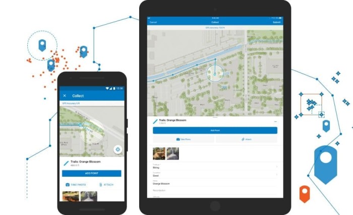
The Collector for ArcGIS application is that better way. Collector is a mobile application built to run on any phone or tablet device. Free to download from whichever App Store you choose, the application can be configured to sync with either an ArcGIS Enterprise environment, like the one housed at AEW, or an ArcGIS Online organizational account that you may have set up on your own. The power of this tool lies in its versatility, allowing you to collect field information on any data set you may have in your GIS database. The interface is intuitive, allowing you to step through the fields in your form and enter information interactively via the devices’ keyboard or from preconfigured dropdown lists, minimizing data entry errors. And the best part, there is no middle man. Once the data is collected in the field, that information is immediately available to anyone within your organization with GIS access.
AEW Case Study
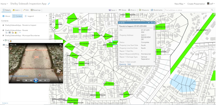
Recently, AEW configured the Collector App for use on a sidewalk replacement program in Shelby Township. After the sidewalk flags needing replacement were identified and marked for removal, AEW personnel walked the sidewalk district, recording the length and width of each flag to be replaced on a parcel by parcel basis. The reason for replacement and slab thickness were also collected, along with notes and photographs of each flag slated for removal. A video, taken from property line to property line, of each parcel requiring work was also recorded and attached to the parcel in GIS. Because these media files were immediately accessible through AEW’s GIS Portal, Township staff were able to virtually “walk” the property whenever resident questions arose, eliminating the need for field visits. Once all the field data collection was completed, a quick and accurate calculation of total square footage of sidewalk to be replaced was calculated via a simple query of the GIS database.
This project is but one example of the flexibility that Collector provides. AEW has shaped numerous other field applications built on this technology, including ones for manhole inspection, lead water service identification, sewer repair activities, and catch basin cleaning tracking, just to name a few. These solutions have dramatically streamlined the process of moving data from the field to the office, improved the speed and accuracy of the data collection, and made near real-time, anywhere access to the information a reality.
If you would like to learn more about how Collector for ArcGIS can be configured for your organization, please feel free to reach out to me at jmmiller@aewinc.com.

Jeff Miller started his career at AEW as a GIS Specialist in 2006, becoming the GIS Manager in 2015. His work in the GIS field has taken him from Fenton, MI to Boca Raton, FL to Mesa, AZ, and finally back to AEW (just testing out retirement locations, apparently…). Jeff graduated from Central Michigan University in 2004 with a degree in Geography with GIS and Land Use Planning concentrations. When he isn’t administering AEW’s Enterprise GIS environment, he enjoys playing all sports, camping, listening to GOOD music and learning to play the piano, albeit very slowly…